Southern Corsica is a constant invitation to discovery, a land where wild and unspoiled nature offers spectacles of striking beauty. While the idyllic beaches attract many visitors, it is by exploring its hiking trails that one truly penetrates the soul of this unique region.
For nature lovers and walking enthusiasts, exploring the island in a different way means venturing beyond the postcards, to encounter magnificent landscapes, exceptional biodiversity and a heritage steeped in history.
From coastal paths overlooking a turquoise sea to alpine trails challenging granite peaks, Southern Corsica boasts an unparalleled network of hiking trails. This guide offers a selection of the most beautiful hikes for an authentic immersion.
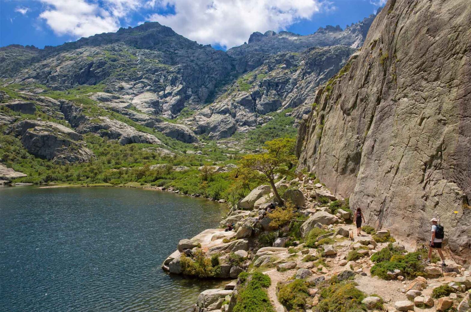
One of the most beautiful ways to discover South Corsica on foot is to take the coastal paths . The one that connects Campomoro to Tizzano , in the Gulf of Valinco, is particularly remarkable for its wild and unspoiled character. Managed by the
Conservatoire du Littoral, this route winds for around 15 kilometers along a jagged granite coast, offering constant maritime panoramas and access to a succession of isolated coves with crystal-clear waters.
It is a flexible hike, which can be done in its entirety (allow 5 to 6 hours one way) or in sections for shorter walks.
The departure from the majestic Genoese tower of Campomoro sets the tone: the route immediately plunges into a dense and fragrant scrubland, where the scents of immortelle and myrtle accompany the walker.
The trail, although generally accessible, has some more technical passages on the rocks and a significant cumulative difference in altitude . Each climb is, however, rewarded by breathtaking views of the bay of Campomoro and then the open sea , with the silhouette of Sardinia sometimes appearing on the horizon on a clear day.
This hike is a true immersion in the Mediterranean coastal nature . Far from any buildings, you will move through a landscape shaped by the wind and sea spray, where the sculpted rock interacts with resilient vegetation.
The many coves, such as Cala d’Agulia or Cala di Conca , irresistibly invite you to take a refreshing swim. It is worth noting that this path, although popular with those in the know, remains relatively uncrowded compared to the star beaches of the far south , thus offering a pleasant experience of tranquility , even in summer.
Remember to bring plenty of water, as there are no refreshment points along the route.
Bonifacio ‘s surroundings on foot offers unique perspectives on this spectacular citadel and its famous limestone cliffs. Several hiking trails , often shorter and more accessible than the main coastal routes, allow you to admire this exceptional site from different angles.
The Campu Rumanilu and Pertusatu trail , starting from the Saint-Roch chapel near the upper town, is undoubtedly the best known. This easy loop of around 2 to 3 hours runs along the top of the cliffs, offering dizzying views of the Strait of Bonifacio and nearby Sardinia.
The path crosses a limestone plateau covered with low, windswept scrubland, where the flora has adapted to these extreme conditions. There you will discover striking panoramas of the perched citadel, the port strait , and astonishing rock formations such as the “Grain de Sable” or the “Governail de la Corse”.
The intense light and the contrast between the bright white of the rock and the deep blue of the sea create landscapes of striking mineral beauty. It is also an excellent observation point for seabirds that nest in the cliffs.
Another interesting option is to explore the Arinella trail , which descends from the upper town to a small beach nestled at the foot of the cliffs. This shorter (about 1 hour round trip) but quite steep hike offers a different perspective , from sea level, on the imposing citadel.
Whichever route you choose, hiking around Bonifacio is an unforgettable experience that combines spectacular natural beauty with immersion in a site steeped in history. However, caution should be exercised on cliff-edge trails , especially in strong winds, and avoid getting too close to the edge.
The site of Roccapina , famous for its granite rock in the shape of a lion watching over a bay with turquoise waters, is also an excellent starting point for hikes allowing you to explore the island in a different way .
Far from being limited to the main beach , which is often very busy in summer, the surrounding area offers several hiking loops through the scrubland, leading to exceptional viewpoints and more confidential coves . These routes allow you to fully appreciate the wild beauty of this coastline in southwestern Corsica.
A popular loop starts from the Roccapina beach car park and climbs to the Genoese tower that dominates the site. This short but fairly steep climb (about 30-40 minutes) offers an immediate reward: a 360-degree panorama of Roccapina Bay on one side, and Erbaju beach on the other, one of the longest and wildest in Corsica.
The path then continues on a balcony above the sea, crossing dense scrubland where the scents of rockrose and wild lavender are omnipresent.
For more industrious walkers, it is possible to reach Erbaju beach via a longer path that goes around the tip of Roccapina. This beach, accessible only on foot or by sea, is a true haven of peace , even in the height of summer. Its vast expanse of fine sand and crystal-clear waters invite you to take a long, contemplative break.
Imagine that this area is part of the sites protected by the Conservatoire du Littoral , thus guaranteeing the preservation of its wild character . Hiking around Roccapina is therefore a perfect combination of discovering an emblematic site, moderate physical effort and access to natural spaces of preserved beauty.
Bavella massif is a must-see for any nature lover visiting southern Corsica . These “Corsican Dolomites,” with their jagged pink granite peaks rising above deep forests, offer a magnificent natural spectacle and an exceptional playground for hiking . Several routes of varying difficulty allow you to explore this major site in the Corsican Regional Natural Park.
For an accessible first approach, the Trou de la Bombe (U Cumpuleddu) loop is ideal. Starting from the Col de Bavella (1218 m), this family-friendly trail, approximately 2 hours round trip, leads to a spectacular natural arch carved into the granite, offering a unique “window” onto the landscape.
The path crosses a beautiful Corsican pine forest and already offers beautiful views of the surrounding peaks. It’s an excellent introduction to the alpine atmosphere of Bavella.
For more experienced hikers, there are plenty of options. The Alpine variant of the GR20 , which passes at the foot of the Aiguilles, is a technical challenge with sections equipped with chains and ladders, reserved for seasoned mountaineers.
Other routes, such as the hike to the Purcaraccia waterfalls (attention, access is regulated and difficult, guide recommended) or the climb to the Paliri refuge , offer deeper immersions in the massif. It should be noted that the beauty of Bavella also lies in its changing lights , particularly striking at sunrise and sunset , when the granite takes on flamboyant hues.
Planning a hike in this massif requires good preparation: suitable equipment, checking the weather (which can change very quickly in the mountains) and sufficient water.
The Coscione Plateau (U Cuscionu) offers a completely different hiking experience , an immersion in a unique high-altitude ecosystem in South Corsica . Located between 1500 and 1800 meters, this vast undulating plateau is characterized by its pozzines , these thick, spongy lawns dotted with sparkling water holes.
It is a surprising, almost unreal landscape, where one feels far from the hustle and bustle of the Mediterranean coast. Access is generally via tracks from Quenza or Zicavo, often requiring a suitable vehicle or an approach walk.
Once on the plateau, hiking opportunities are vast, although the trails are sometimes poorly marked. Exploration is often done “by sight,” navigating between grassy knolls and streams that wind through the pozzines.
The Bassetta sheepfold loop is a classic route that allows you to discover the heart of the plateau and observe the herds of cows, horses and pigs that live there in semi-freedom . This significant animal presence contributes to the peaceful and timeless atmosphere of the Coscione.
The flora is also remarkable, with many endemic species adapted to the harsh climate of the altitude, which color the plateau with a thousand flowers in spring and early summer. The silence, the immensity and the particular light of this place make it a privileged spot for photographers and hikers in search of solitude and contemplation.
However, it is advisable to be well prepared: orientation can be difficult in foggy weather (frequent), and mountain equipment (warm and waterproof clothing) is essential, even in summer. The Coscione is an essential hike for those who want to explore the island in a different way , away from the crowds and closer to wild and unspoiled nature.
For seasoned hikers looking for a challenge and ultimate panoramas, climbing Monte Incudine (Alcùdina) is a major hike in South Corsica . At 2,134 meters, it is the highest peak in the south of the island.
Its ascent offers a complete alpine experience, with varied landscapes and an absolutely breathtaking 360-degree final view , embracing a large part of Corsica, from the Tyrrhenian Sea to the Sardinian Sea.
There are several routes to reach the summit. The most common approach is from the Coscione plateau , via the Bassetta sheepfolds or the Matalza refuge. This option, although long (allow a full day), has a more gradual difference in altitude.
A more direct and steeper alternative starts from the Col de Bavella , taking a variant of the GR20. This route is more technically and physically demanding, but offers spectacular views of the Aiguilles de Bavella throughout the climb.
Whichever route you choose, the final ascent to the summit is rocky and requires careful attention. The reward at the top is worth the effort: an immense panorama of the Corsican mountains, deep valleys, and the two seas that frame the island.
Standing on the roof of southern Corsica provides a sense of accomplishment and an intense connection with the power of the surrounding nature. This hike is reserved for experienced hikers in excellent physical condition and well-equipped. The ideal time is from June to October, excluding periods of snow.
It is essential to check the weather forecast before leaving and to be prepared for potentially difficult conditions (wind, cold, fog) even in summer.
The natural pools carved out by rivers are one of the hidden charms of Southern Corsica , offering oases of freshness that are particularly appreciated during hot summer days. The Cavu Valley , located a short distance from Sainte-Lucie de Porto-Vecchio, is undoubtedly the most accessible and family-friendly site to discover these aquatic wonders.
An easy track runs along the river for several kilometers, providing access to a succession of pools with clear, emerald water, interspersed with small waterfalls and pebble beaches.
Hiking along the Cavu River is an ideal outdoor activity for families. The trail is flat or gently rolling, and you can choose to stop at the first pools or continue further upstream to find quieter spots.
swimming opportunities , with shallow areas perfect for young children and deeper pools for a few jumps from the rocks (always with caution and after checking the depth). The lush vegetation on the banks , made up of alders, holm oaks and scrub, provides welcome shade.
It’s worth noting that this site, a victim of its own success, can be very busy in July and August. For a more peaceful experience, visit on weekdays, early in the morning or late in the afternoon. Some sections further upstream, accessible after a slightly longer walk, often remain quieter.
Remember to bring water-safe shoes so you can walk on the pebbles and explore the various pools safely. This is a refreshing and fun hike , perfect for introducing children to the joys of Corsican nature.
The Piscia di Gallu waterfall (literally “cock’s piss” in Corsica) is one of the highest and most impressive waterfalls in Southern Corsica . Located in the Ospédale forest , it is the objective of a popular hike but which requires a certain effort.
The trail, about 5 kilometers round trip, starts near Lake Ospedale and goes into a magnificent Corsican pine forest . The first part is relatively easy, on a wide, shaded path.
The difficulty is concentrated in the last part of the descent towards the waterfall. The path becomes steeper, rockier and technical , requiring the use of hands in places and good vigilance, especially with children.
It is essential to wear sturdy walking shoes. After about an hour of descending, you reach a lookout point offering a spectacular view of the waterfall , which drops over 60 meters down a reddish rock face. The spectacle is particularly impressive in spring or after heavy rains, when the flow is high.
It is possible to continue down to the foot of the waterfall to enjoy the cool sea spray, but this last section is even more technical and slippery. The climb back up, although on the same path, requires sustained effort due to the slope.
This hike, rated as medium difficulty, is a great adventure for families with children who are already a bit of a walker (from around 8-10 years old). It’s a must-do for nature lovers who appreciate forest landscapes and the power of water features.
Exploring the hinterland of Sartène , considered “the most Corsican of Corsican towns” , offers a unique immersion in the deep identity of Southern Corsica . The hiking trails that crisscross the surrounding granite hills cross a particularly dense and fragrant scrubland , and lead to the discovery of vestiges of a rich agro-pastoral and historical past.
It’s a more intimate and cultural approach to hiking, where every stone seems to tell a story.
Several hiking trails start from the area around Sartène or from nearby villages such as Granace or Foza. These routes often follow old mule tracks, lined with dry stone walls, which once connected hamlets and cultivated areas .
Here, you’ll discover ruined sheepfolds (stazzi), circular threshing floors (aghje), and abandoned cultivation terraces (lenze), silent witnesses to a once-flourishing rural economy that has now largely disappeared. Walking these trails is like taking a true journey through time, encountering a moving vernacular heritage.
Hiking in the Sartenais maquis is also an intense sensory experience. The scents of immortelle, rockrose, myrtle , and rosemary are omnipresent, particularly powerful on hot summer days. The landscape, although sometimes seeming austere with its granite chaos and low vegetation , reveals a wild beauty and fascinating resilience.
These hikes, often little frequented, offer absolute tranquility and a deep connection with the soul of rural Corsica . However, they require good orientation (the markings can be random) and preparation adapted to the heat and the sometimes difficult terrain.
Alta Rocca , a mid-mountain region in the heart of southern Corsica , is not only a paradise for hikers in search of alpine landscapes; it is also a high place of Corsican prehistory .
Several major archaeological sites , dating from the Neolithic and Bronze Ages, are accessible via hiking trails, allowing you to combine naturalist discovery with immersion in a mysterious and fascinating past. For nature and history lovers, these routes offer a double reward.
The site of Cucuruzzu and Capula , near Levie, is undoubtedly the most emblematic. An easy hiking loop of about 1.5 hours allows you to discover these two castellu (fortified dwellings) from the Bronze Age, remarkably preserved in a magnificent forest setting (holm oaks and chestnut trees).
The trail is laid out and punctuated with explanatory panels that help you understand the organization of these prehistoric villages and the lives of their inhabitants. A visit to the Levie Archaeological Museum is the perfect complement to this discovery.
Further south, near Sartène, the megalithic alignments of Cauria (Fontanaccia dolmen, Stantari and Rinaghju alignments) bear witness to an even older occupation, dating back to the Neolithic period. These sites, accessible by short, easy walks from the road, exude a special atmosphere with their sculpted menhirs (statue-menhirs) erected in the middle of the scrubland.
Although less spectacular than the Breton sites, they are no less moving and bear witness to the richness of Corsican prehistoric heritage . Combining a visit to these sites with longer hikes in the surrounding area allows you to forge links between the current landscapes and the thousand-year-old history of human occupation of the island. It is an original and enriching way to explore Southern Corsica in a different way .
A successful hike in South Corsica , even on an easy route, begins with good preparation and suitable equipment . The basics are a pair of comfortable hiking boots with good grip. Forget sandals or city shoes; the Corsican terrain is often rocky. A lightweight backpack large enough to hold the essentials is also essential.
Water is important : plan on at least 1.5 to 2 liters per person for a day’s walk in summer, or even more for long or difficult routes. Springs are rare and often dry during the hot season. Also bring sun protection : a hat or cap, sunglasses, and a high-factor sunscreen. Even on cloudy days, UV rays can be intense.
Don’t forget a small first aid kit (bandages, disinfectant, bandages, painkillers), a detailed map of the route (don’t rely solely on your phone, which may have a weak battery or network) and a charged phone .
Energy-boosting snacks ( dried fruit, cereal bars) are useful for maintaining your energy levels. Finally, warm clothing (fleece) and a waterproof windbreaker are recommended, even in summer, especially for mountain hikes where the weather can change quickly.
Hiking in South Corsica requires respecting certain safety rules and preserving the exceptional environment you’re traveling through. Always check the weather forecast before setting out and avoid any storms or strong winds forecast.
In summer, leave early in the morning to avoid the hottest hours and the increased risk of fire. Check for possible restrictions on access to forested areas during periods of drought.
Always stay on marked trails . Straying from the paths increases the risk of getting lost, damaging fragile vegetation, and disturbing wildlife. Take out all your waste without exception, including organic waste (fruit peels, etc.), which takes a long time to decompose. Do not pick flowers; many are rare or protected. Never light a fire .
Be discreet to avoid scaring wild animals and observe them from a distance. Close gates after you pass through grazing areas. Do not swim in drinking water reservoirs.
By adopting these responsible behaviors, you help preserve the beauty and natural richness of these must-see spots for future generations. Always inform someone of your itinerary and your expected return time.
It’s subjective, but crossing the Aiguilles de Bavella (via the alpine variant of the GR20 for experts) or exploring the Coscione plateau offer unique landscapes and ecosystems that are particularly striking. For the coast, the path from Campomoro to Tizzano or the views from the cliffs of Bonifacio are exceptional.
Wildlife observation requires patience and discretion. Mouflon can be seen in the mountains (Bavella, Incudine), especially early in the morning. Birds (including the Corsican nuthatch in the pine forest) are easier to observe. Hermann’s tortoises can be encountered on sunny trails. Dolphins can be seen from some coastal paths or during sea excursions. The key is to walk quietly and be attentive.
Yes, there are several developed botanical trails, such as the one in the Pinia forest on the east coast or thematic trails offered by mountain guides specializing in Corsican flora. Spring (April-June) is the ideal time to admire the rich blooms of the maquis and high-altitude grasslands.
Never drink water from rivers or springs without treatment (filter or disinfectant tablets), even if it appears clear. The risk of contamination by herds is real. Always carry a sufficient supply of water (minimum 1.5L/person/day, more in summer). Identify reliable water sources (village fountains) before setting off on long hikes.
For well-marked trails of moderate difficulty, a guide is not essential if you are an experienced hiker with a good map and/or GPS. However, for off-trail routes, technical routes (GR20 alpine variant, some waterfall accesses) or for an in-depth discovery of the fauna, flora and heritage, accompaniment by a local professional (Mountain Guide) is strongly recommended and considerably enriches the experience.
The basic rules are: leave no trace (take all your waste with you), stay on marked trails , do not pick plants or disturb animals, do not make fires, use dry toilets when available or move away from water points and trails for your natural needs (by burying excrement and paper). Favor reusable water bottles over plastic bottles. Choose accommodation and service providers committed to an ecological approach.